

Sección C: Ingenierías
Land Acquisition and Resettlement Action Plan (LARAP) of Tukul Dam Project, Pacitan, East Java, Indonesia
Plan de Acción para la Adquisición de Tierras y el Reasentamiento (LARAP) del Proyecto de la Presa de Tukul, Pacitan, Java Oriental, Indonesia
ACI Avances en Ciencias e Ingenierías
Universidad San Francisco de Quito, Ecuador
ISSN: 1390-5384
ISSN-e: 2528-7788
Periodicity: Bianual
vol. 15, no. 2, 2023
Received: 25 October 2023
Accepted: 21 December 2023
Corresponding author: chairul.muharis@polinema.ac.id

Abstract: The Tukul Dam is a development project in Pacitan, East Java, Indonesia. This project is planned to acquire land belonging to residents around the project and for the government to resettle affected residents in appropriate places. This research presents a comprehensive analysis of the Land Acquisition and Resettlement Action Plan (LARAP) for the Tukul Dam Project in Pacitan, East Java, Indonesia. The study involves a survey of 140 affected families to understand their awareness of the project, willingness to relocate, and expectations regarding compensation. The paper provides detailed information about the project, the affected area, the types of losses incurred by residents, compensation policies, and the implementation process. It concludes by offering suggestions for improving the compensation process and emphasizes the significance of considering the well-being of landowners. This research contributes to the existing literature on land use policy, irrigation, water stress, and land acquisition, and provides valuable insights for future projects in similar contexts.
Keywords: Construction, Irrigation, Tukul Dam.
Resumen: La presa Tukul es un proyecto de desarrollo en Pacitan, Java Oriental, Indonesia. Se planea adquirir terrenos pertenecientes a los residentes alrededor del proyecto y el gobierno reasentará a los residentes afectados en lugares apropiados. Esta investigación presenta un análisis integral del plan de acción de adquisición de tierras y reasentamiento (LARAP) para el Proyecto de la Represa Tukul en Pacitan, Java Oriental, Indonesia. El estudio implica una encuesta de 140 familias afectadas para comprender su conocimiento del proyecto, su voluntad de reubicarse y sus expectativas con respecto a la compensación. El documento proporciona información detallada sobre el proyecto, el área afectada, los tipos de pérdidas sufridas por los residentes, las políticas de compensación y el proceso de implementación. Concluye ofreciendo sugerencias para mejorar el proceso de compensación y enfatiza la importancia de considerar el bienestar de los propietarios de tierras. Esta investigación contribuye a la literatura existente sobre políticas de uso de la tierra, riego, estrés hídrico y adquisición de tierras, y proporciona información valiosa para proyectos futuros en contextos similares.
Palabras clave: Construcción, Riego, Presa Tukul.
INTRODUCTION
Land acquisition refers to the process of acquiring land for various purposes, such as public use, conservation, or development. The land acquisition process varies depending on the purpose and the country or state where it takes place [1]. The Land Acquisition and Resettlement Action Plan (LARAP) is a plan developed for projects that involve the acquisition of land and the resettlement of affected individuals. It aims to address the negative impacts of such projects and ensure that the affected people are properly compensated and resettled. The plan includes various measures to mitigate the impacts by, for example, providing compensation for the acquisition of land and temporary occupation of construction land [2].
Tukul Dam is part of the 61 dam construction projects in Indonesia. Tukul Dam is planned to be built by the Center for Bengawan Solo River Region which is located in Pacitan. Tukul Dam is expected to give the benefits of irrigation of 600 hectares, raw water of 300 lt/sec for micro hydro of 2 x 132 KW, and is expected to reduce the risk of flood up to 44.86 m3/sec. The approach and drought disaster factor is one of the determinants to prioritize irrigation to optimize the irrigation system [3].
The construction of Tukul Dam in macroeconomic discourse is related to the acceleration of economic development in East Java as previously stated in Presidential Regulation of Republic Indonesia Number 80/2019. The regulation stated that the principle of national economic development is inseparable from equitable development in all regions. To achieve national equal development in Indonesia, regional improvement must be made so that interregional growth and the growth rate will be equal between urban and rural areas. The acceleration of regional development will significantly contribute to the acceleration of national economic growth.
In the context of accelerating the development of East Java Province, it is necessary to prepare a Master Plan for the Acceleration of Economic Development (Rencana Induk Percepatan Pembangunan Ekonomi or RIPPE) for the areas of Gerbangkertosusila, Bromo-Tengger-Semeru, Selingkar Wilis, and Lintas Selatan without neglecting principles of sustainable development. The Tukul LARAP project was implemented following the context of the accelerated development of East Java. The acceleration and distribution of economic development is expected to realize the quality of sustainable development by increasing the quality of life for all people in East Java Province and nationally.
The construction of an irrigation system within the region of Tukul Irrigation located in Pacitan Regency, East Java is displayed in the map below:
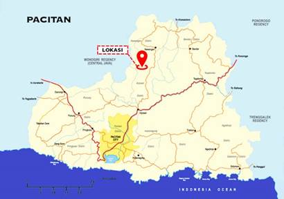
The construction of Tukul irrigation will definitely affect the surrounding region, which is Pacitan Regency. The area of Pacitan Regency is 1389.87 km2 and consists of dry land with an area of 1259.72 km2 and a rice field area of 130.15 km2. Pacitan is divided into 12 sub-districts, five urban villages, and 166 villages. The topography of Pacitan Regency consists of hills, mountains, and steep ravines, as well as Seribu mountain. Pacitan Regency shares borders on the north with Ponorogo Regency and Wonogiri Regency, on the east with Trenggalek Regency, on the south with the Indian Ocean, and on the west with Wonogiri Regency.
Tukul Dam is located in Kali Brungkah, Karanggede Village, Arjosari Sub-district, Pacitan Regency, East Java, ±25 km from the north impact of Pacitan Regency with coordinates of 8°3’28.48”S and 111°8’36.35”E. Tukul dam is used to supply water to 30 existing irrigation areas downstream of the dam with a total area of 1,230.70 Ha. Besides, there is a potential irrigation area in the form of a rainfed paddy field and garden or moorland or heath downstream of the dam with an area of 126.73 Ha. The concept of “precision agriculture”is used to define technologies that support customized agricultural practices aimed at higher efficiency and a lower impact on the environment [4].
The population of Pacitan Regency is 589,108 people, with a male population of 49.35% and a female population of 50.65%. Local communities interpret the resulting social impact experiences as a curse on local resources. The impacts have given rise to social conflict among the affected communities [5]. Meanwhile, the right approach is needed to avoid conflicts that impact society. Agricultural land is increasingly being lost due to the development of industrialization in Vietnam’s province [6].
This research purpose is to examine the awareness and willingness of affected residents to relocate, as well as their expectations regarding compensation. It also seeks to provide detailed information about the project, the affected area, the types of losses incurred by residents, compensation policies, and the implementation process. It provides a comprehensive analysis and understanding of the Land Acquisition and Resettlement Action Plan (LARAP) for the Tukul Dam Project in Pacitan, East Java, Indonesia. While there may be existing studies on land acquisition and compensation policies, this paper aims to fill the gap by providing detailed information about the project, the affected area, types of losses incurred by residents, compensation policies, and the implementation process. This research contributes to the existing literature on land use policy, irrigation, water stress, and land acquisition, and provides valuable insights for future projects in similar contexts.
MATERIAL AND METHODS
This research used qualitative research and emphasized the observation of phenomena and the substantial meaning of these phenomena. Qualitative research focuses on the process and the meaning of the results [7]. It emphasizes the human elements, objects, and institutions, as well as the relationships and interactions between them in the context of understanding the event, behavior, or phenomenon [8].
This study aims to describe the administrative location of the dam and the loss caused by the construction of Tukul irrigation. The research approach used is the Macro study approach. The macro study approach method is a scientific study that integrates a rational method based on previous studies by authorized agencies with an empirical method using a survey technique. This approach is used in sociology, economics, and other disciplines to investigate broad-scale phenomena [9]. The type of data collected includes primary data and secondary data. The secondary data is obtained through various institutions, while the primary data is obtained through observation and direct investigation in the field.
RESULT
There are several losses as a consequence of the land acquisition. The types of losses as a consequence of the construction of Tukul irrigation that are generally caused by the land acquisition can be seen in the table below:
| No. | Category | Types of losses |
| 1 | Land | Agricultural land Residential land Yards Access to the work location (e.g., woods) Traditional rights Community land or meadows |
| 2 | Building | Housing and settlements Other physical buildings Buildings used for commercial or industrial purposes Land acquisition from rented or occupied commercial land |
| 3 | Income and livelihood | Income from the plants Income from the rent or profit-sharing Income from the wage or salary Access to the work location Income from long-lived trees or plants Income from forest products Income from the fish pond Income from the meadow The livelihood from one of the sources of income |
| 4 | The location of public facilities and cultural heritage | Schools, community activity centers, markets, health centers Sanctuaries, symbols, or other sacred places Places of worship Graves and cemetery areas Rights to get food, medicines, and natural resources Intellectual property rights |
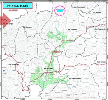
The survey was administered to every head of family in one particular regency, two sub- districts, and seventeen villages, namely:
a. Arjosari sub-district, consisting of:
1. Karanggede Village
2. Karangrejo Village
3. Gayuhan Village
4. Jatimalang Village
5. Tremas Village
6. Arjosari Village
7. Pagutan Village
8. Gunungsari Village
9. Sedayu Village
b. Pacitan sub-district, consisting of:
10. Tambakrejo Village
11. Banjarsari Village
12. Purworejo Village
13. Mentoro Village
14. Menadi Village
15. Nanggungan Village
16. Widoro Village
17. Semanten Village
The survey location included the Tukul Irrigation Network Area, which consists of one regency, two sub-districts, and seventeen villages. The number of respondents to the socio-economic survey on the construction of Tukul Irrigation Network was 140 heads of families. The affected area in Arjosari sub-district measures 113,680.23 m2 , and that of Pacitan sub-district measures 35,663.43 m2. Hence the total affected area is 149,343.66 m2. The majority livelihood of the respondents is farming (70%), followed by entrepreneurship (17%). The education level of the respondents is predominantly high school/equivalent level graduates (43%), followed by middle school/equivalent level graduates (27%). From the percentage mentioned, it can be concluded that the local citizens took formal education from the primary level to the secondary level. Every respondent in this survey knew information about the Construction of Tukul Irrigation Network plan. The information was obtained through village officials and local neighbors. Affected residents approved the construction plan with the hope of compensation for the affected land according to the price agreement between the affected residents and the government.
Table 2 demonstrates the results of the survey on the compensation policy and proper resettlement for the affected residents.
| No. | Types of losses | Application | Entitled party | Compensation Policy | Implementation |
| 1. | Loss of land containing crops | Land containing crops in the construction area | Farmers working in the particular area | Providing equal land near the original location. If the land is not available, agricultural intensification and diversification will be applied to the available land. | List of land containing crops in the affected area. Aids the farmer to develop and increase the production. |
| 2. | Loss of residential area | Residential area in the area that would be acquired | Legal resident with the certificate from the authority. Illegal residents occupied the area. | If the remaining land is sufficient to accommodate the affected parties, the remaining land in the area will be given. If the remaining land is not sufficient, a house lot as an alternative or an equivalent land to the original land will be offered in the study area. | To avoid the procedural problems due to the absence of written permission or certificates, permission was issued before the compensation process started. The minimum area of land owned by affected parties where they are permitted to re- administer should be regulated by the authority in the Regency or in the particular region. The compensation value must be the same, not less or more than the original property value of the affected parties. |
| 3. | Loss of building | Buildings in the area that would be acquired | Legal owner of the building | Compensation in the form of building materials. The owner will build their building with the aid of technical support. An equal allowance of the loss allowance. The transport of building materials for the relocated families. | Various building materials will be provided for the affected parties. During the survey, the price and types of building materials needed will be evaluated. |
| 4. | Loss of living plants | Plants in the puddle location and the building facilities | Farmer or owner that works on the particular land | Equal compensation on the plants based on the land productivity after it was acquired | The price of agricultural products on the local market must be known for comparison. The affected parties will be informed months prior to the land acquisition. Plants that grow after the announcement will not be compensated. The activity schedule will consider the planting season to avoid the activities during the harvesting season. |
After the survey was conducted, analysis and data review in the simplified form were performed for the decision-makers. From there on, the Matrix of Rights was arranged as the guidelines for the requirements to get the compensation and payment of all types of losses.
DISCUSSION
The construction of a dam could alleviate the problem in population concerning the need for irrigation, flood control, hydroelectric power generation, aquaculture, and tourism. On the other hand, the construction also impacted the loss of productive land. As the main artificial project in the river areas, dams and reservoirs have an important role in mitigating extreme long-term hydrological conditions. The construction of large dams is considered as one of the available means to meet the increasing needs for water, food, and energy in the future, although this may have a major impact on changes in the surrounding natural environment [10]. Similar to the case in Indonesia, Land Acquisition (LA) in India is associated with a development paradigm and economic growth through industrialization [11].
The land acquisition for the public interest, in this case the construction of Tukul dam, is based on the regulations as follows:
1. Law Number 2 of 2012 concerning Land Acquisition for development in the public interests;
2. President’s Regulation Number 71 of 2012 concerning the organizing of land acquisition for development in the public interests (or changes thereto).
In this case, according to the Regulation of Land Agency, every activity performed by the government regarding land acquisition should be based on these regulations. The construction of large infrastructure dominated irrigation expansion in the 20th century [12]. However, this “hard-path” water governance approach with large, centralized, capital-intensive irrigation projects and water storage infrastructure seems vulnerable to the volatile condition of sociohydrology, known for impacting the socioenvironmental condition through destruction of habitats, displacement of humans, and alteration of sediment and hydrologic regimes [13].
The basic principle of the Indonesian government is that land acquisition processes should be implemented with consideration for humanity, democracy, and justice. Regarding this principle, land acquisition should not be implemented without justice or if it violates any human rights. This is stipulated in Article 2 of the Law of Land Acquisition and can simply be understood that land acquisition for the development of public interests shall not be detrimental to any party. Economic reform in China has resulted in rapid urbanization over the past three decades, changing the urban and rural landscape dramatically. A large amount of farmland was developed, leading to conflict between construction demand and farmland protection [14].
The detailed survey of all the losses due to the construction project includes settlements, land, plants, gardens, farming areas, and other cultural heritages. A survey from the government needs to estimate the land acquisition and other assets including the income losses, whether it is temporary or permanent. In this case, it includes looking for other sources of alternative jobs for the affected community parties, e.g., irrigation network construction worker, fish farmer in the irrigation network area, or small-scale supplier for the household needs in the new area, et cetera.
This project must describe the field map based on the survey results and regional mapping where the affected community must be relocated. The map can depict the affected households in detail, so they can be marked. Consequently, a survey on the land and land mapping according to its purpose needs to be conducted. The land is categorized as potential land for agriculture and farming, et cetera. From the map observation, various thematic location and land use maps can be attached.
The construction of dams and reservoirs is primarily prompted by population growth and its consequence of the increase in consumption of water, food, and energy [15, 16]. In this context, the construction of a dam possibly impacted the environment. However, people’s needs and livelihoods are inevitable, hence, the Indonesian government decided to continue the construction of dams in Indonesia, one of them being the Tukul Dam in Pacitan, East Java. A probable environmental impact caused by the construction of the dam in Pacitan is local climate change. Large-scale dam construction played a role in limiting the rise of sea levels [17]. A previous study found that dams almost stopped the rise of sea level in the 1970s since the dams prevented so much water from entering the ocean [18]. The government could take this study as a consideration in making policies.
CONCLUSION
Based on the result and discussion above, this research provides a comprehensive analysis of the land acquisition and resettlement action plan for the Tukul Dam Project in Pacitan, East Java, Indonesia. It highlights the awareness and willingness of affected residents to relocate, as well as their expectations regarding compensation. It offers valuable insights into the project’s implementation process, compensation policies, and the importance of considering the well-being of landowners. Moreover, it concludes by suggesting improvements for the compensation process and contributes to the existing literature on land use policy, irrigation, water stress, and land acquisition.
SUGGESTIONS
The consideration of compensation for the affected parties, particularly the building and land compensation of the construction of the Tukul Irrigation Network, is expected to be based on the agreement or discussion with the affected community parties. LARAP activity on the construction of the Tukul Irrigation Network in Pacitan Regency is expected to review the previous LARAP activities. These functions simultaneously encompass the financial, social, political, and personal aspects of landowners’ well-being and are grouped under five categories: (i) being able to secure basic necessities for life, (ii) being financially secure, (iii) being able to protect oneself from discrimination, exploitation, violence, and assault, as a fundamental human right, (iv) being able to establish social associations and harness personal, familial, and societal interests through these associations, and (v) being able to maintain and enhance self-respect and identity [19].
REFERENCES
[1] St. Johns River. (2023). Land acquisition. Water Management District.
[2] Sapre, A. A. y Gori, S. (2023). The Predicament of Land Acquisition, Displacement and Resettlement: An Analysis of Indian Scenario. Journal of Asian and African Studies. doi: https://doi.org/10.1177/00219096231179651
[3] Dewantoro, M. D. R. (2013). Spatial Approach on Determination of Irigation Priority Area on Dry Seasion. Jurnal Irigasi, 8(1), 59–71. doi: https://doi.org/10.31028/ji.v8.i1.59-71
[4] Kittas, C., Elvanidi, A., Katsoulas, N., Ferentinos, K. P. y Bartzanas, T. (2016). Reflectance indices for the detection of water stress in greenhouse tomato (Solanum lycopersicum ). Acta Horticulturae, 1112, 63–70. doi: https://doi.org/10.17660/ActaHortic.2016.1112.9
[5] Ogwang, T., Vanclay, F., y van den Assem, A. (2019). Rent-Seeking Practices, Local Resource Curse, and Social Conflict in Uganda’s Emerging Oil Economy. Land, 8(4), 53. doi: https://doi.org/10.3390/land8040053
[6] Nguyen, T. T., Hegedűs, G. y Nguyen, T. L. (2019). Effect of Land Acquisition and Compensation on the Livelihoods of People in Quang Ninh District, Quang Binh Province: Labor and Income. Land, 8(6), 91. doi: https://doi.org/10.3390/ land8060091
[7] Basri, H. (2014). Using Qualitative Research in Accounting and Management Studies: Not a New Agenda. Journal of US-China Public Administration, 11(10), 831–838. doi: https://doi.org/10.17265/1548-6591/2014.10.003
[8] Mohamed, Z. M., Abdul Majid, A. H. y Ahmad, N. (2010). Tapping New Possibilities in Accounting Research, Qualitative Research in Accounting- Malaysian Cases. Universiti Kebangsaan Malaysia.
[9] Schneider, C. Q. (2019). Macro-Qualitative Approaches. In The Handbook of Political, Social, and Economic Transformation (pp. 173–180). Oxford University Press. doi: https://doi.org/10.1093/oso/9780198829911.003.0017
[10] Zhao, Y., Liu, S. y Shi, H. (2021). Impacts of dams and reservoirs on local climate change: a global perspective. Environmental Research Letters, 16(10). doi: https://doi.org/10.1088/1748-9326/ac263c
[11] Bhagat-Ganguly, V. y C., S. (2016). Special Issue on Land Acquisition, Rehabilitation and Resettlement in India. Journal of Land and Rural Studies, 4(1), 1–2. doi: https://doi.org/10.1177/2321024915616668
[12] François Molle, Peter P. Mollinga y Philippus Wester. (2009). Hydraulic Bureaucracies and the Hydraulic Mission: Flows of Water, Flows of Power. Water Alternatives, 2(3), 328–349.
[13] Rosa, L., Chiarelli, D. D., Sangiorgio, M., Beltran-Peña, A. A., Rulli, M. C., D’Odorico, P. y Fung, I. (2020). Potential for sustainable irrigation expansion in a 3 °C warmer climate. Proceedings of the National Academy of Sciences, 117(47), 29526–29534. doi: https://doi.org/10.1073/pnas.2017796117
[14] Cheng, L., Brown, G., Liu, Y. y Searle, G. (2020). An evaluation of contemporary China’s land use policy – The Link Policy: A case study from Ezhou, Hubei Province. Land Use Policy, 91, 104423. doi: https://doi.org/10.1016/j.landusepol.2019.104423
[15] Chen, J., Shi, H., Sivakumar, B. y Peart, M. R. (2016). Population, water, food, energy and dams. Renewable and Sustainable Energy Reviews, 56, 18–28. doi: https://doi.org/10.1016/j.rser.2015.11.043
[16] Shi, H., Chen, J., Liu, S. y Sivakumar, B. (2019). The Role of Large Dams in Promoting Economic Development under the Pressure of Population Growth. Sustainability, 11(10), 2965. doi: https://doi.org/10.3390/su11102965
[17] McGrath, M. (2020). Climate change: Dams played key role in limiting sea level rise. BBC News. https://www.bbc.com/news/science-environment-53836018
[18] Frederikse, T., Landerer, F., Caron, L., Adhikari, S., Parkes, D., Humphrey, V. W., Dangendorf, S., Hogarth, P., Zanna, L., Cheng, L. y Wu, Y.-H. (2020). The causes of sea-level rise since 1900. Nature, 584(7821), 393–397. doi: https://doi. org/10.1038/s41586-020-2591-3
[19] Rao, J. (2019). A‘capability approach’to understanding loses arising out of the compulsory acquisition of land in India. Land Use Policy, 82, 70–84. doi: https://doi.org/10.1016/j.landusepol.2018.11.042
Author notes
chairul.muharis@polinema.ac.id